NCRGE Welcomes Abstracts for a Special Track During AAG 2018 New Orleans
Transformative Research in Geography Education
For the 2018 AAG Annual Meeting in New Orleans, the National Center for Research in Geography Education (NCRGE) is welcoming abstracts and organized session proposals for a special track of sessions on Transformative Research in Geography Education during the AAG Annual Meeting on April 10-14, 2018, in New Orleans. This track aims to raise the visibility of research in geography education, grow the NCRGE research coordination network, and provide productive spaces for discussion about geography education research and the notion of what makes research in the field potentially transformative.
CONTEXT: In 2007, NSF adopted the following working definition of “transformative research”:
Transformative research involves ideas, discoveries, or tools that radically change our understanding of an important existing scientific or engineering concept or educational practice or leads to the creation of a new paradigm or field of science, engineering, or education. Such research challenges current understanding or provides pathways to new frontiers.
The concept of transformative research pervades the Road Map for 21st Century Geography Education project’s landmark report on geography education. By organizing new networks of geographers, educational researchers, and practitioners, the NCRGE research coordination network aims to build capacity for research in areas of geography education that were deemed by the Road Map Project to be highly significant for achieving broad-scale improvement in educational practices.
SESSIONS: Abstracts and sessions on any geography education research topic are welcome. Examples of topics include:
Integration of Geography and STEM Learning
Project-based learning
Learning progressions
Assessment
Capabilities and powerful knowledge
International comparative research
Professional development (Online & Face-to-Face)
Teaching Strategies (All levels)
For each of the activities below, we seek a diverse group of individuals representing a range of experiences with these and other topics. If interested, please follow the specified procedures.
During abstract submission select “paper” as the abstract type
When you receive confirmation of a successful abstract submission, please then forward this confirmation to ncrge [at] aag [dot] org with “Transformative Research paper abstract” in the subject line.
The abstract deadline is October 25, 2017.
ORGANIZED SESSIONS
To submit an organized session to this theme please forward your session confirmation email to ncrge [at] aag [dot] org by November 8, 2017.
If ever you find yourself at a loss for conversation among a group of geographers, simply ask this one question: Where do you think the AAG should hold its next Annual Meeting? Everyone has an opinion on this question, and embellished memories of past meetings to recount; the only risk of raising this question is that the conversation may well go long into the night.
How the AAG Selects Annual Meeting Sites
Selecting AAG Annual Meeting sites is a lengthy and complex process. I would like to share with you the many steps and considerations that go into Annual Meeting site selection that have been in place for many years. As with most major academic associations, we contract for meeting sites about five to eight years into the future, and in blocks of three or four meetings at a time. This gives us negotiating leverage, minimizes costs, and reduces staff time by consolidating what is a very lengthy and complicated due diligence and negotiation process.
At the outset, the process involves a great deal of AAG member and Council discussion and input, as well as extensive data gathering, past history analysis, cost comparison, staff experience, research, and consultation with our professional conference managers firm, as well as geographical balancing of our meeting sites. We then develop and issue a detailed Request for Proposals (RFP) to several prospective cities, liaison with the bidders, conduct comparative analyses of all proposals, perform physical site inspections, weigh union hotel preferences, and enforce the inclusion of numerous specific contract stipulations that I have developed over the years to protect the AAG. All of these considerations go into the process of narrowing down feasible locations for our AAG Annual Meetings for each calendar year. With a shortlist of promising bids in hand, we then enter into detailed and careful negotiations of myriad contract provisions before signing an agreement with major convention centers and/or large hotels at a proposed site. If we cannot negotiate the costs and legal terms we require and which are favorable to the AAG at an initially preferred site, we are willing to cancel negotiations and start the above process all over again with an alternate potential city.
Finally, once we have completed lengthy negotiations and entered into major contracts for convention centers and/or large hotels at a particular year’s site, we then also must develop specifications and competitively bid out dozens of ancillary contracts for meeting services such as audio-visual services; internet availability; food and beverage obligations; overflow hotels; exhibitor booth agreements and exhibit setup services; special events needs related to workshops, field trips, and supplemental meeting room space; design, construction and setup of meeting registration structures and signage; mobile app and the printed program book; and many other agreements.
Why not small cities?
I frequently am asked why the AAG doesn’t meet in smaller cities such as Ann Arbor or Portland. The fact is that most cities are far too small to host our Annual Meetings. They lack the required number or concentration of hotel rooms and meeting rooms or sufficient airline flights to accommodate our 9,000 attendees. We do have a suite of mid-sized and lower-cost cities that we have used from time to time (most recently Tampa), but ironically these smaller city meetings are among our very lowest-attended meetings despite being our lowest cost venues. So it is not clear that lower venue costs correlate with greater access or attendance (or desirability). Costs of transportation are of course primarily a function of where one lives in relation to the meeting site, rather than the meeting site itself. This is why we try to rotate our meetings among different regions the country, so that each region is involved, and also of course so that geographers can experience many different places.
What about international AAG Meetings?
The AAG has on a few occasions held an Annual Meeting in Canada (Toronto and Montreal). I would love to hold additional AAG meetings in other international locations, from Mexico City to Vancouver to elsewhere. So why not?
One obstacle is that since 9/11, the U.S. borders with Canada and Mexico have become more difficult and uncertain to cross. At the same time, growing numbers of AAG members from other countries now teach or study on visas in the U.S. Many members have expressed concern that if they were to leave the U.S. to attend an Annual Meeting, they may not be able to return easily (or in some cases at all) to the United States. The AAG Council has considered the issue of international Annual Meetings on several occasions during the past decade, and each time the consensus has been it would not be fair to hold the AAG Annual Meeting in a location where a substantial number of our faculty and graduate student members would be unable to attend. It is of course always possible that domestic and international circumstances may change, or that the AAG Council’s position on this issue could change, but for now the consideration of fairness to these many members residing in the U.S. on visas remains the policy.
Controlling Costs at our Annual Meetings
Our conference manager consultants tell us every year that the AAG meetings are the best bargain of any of the dozens of meetings they help organize. We hold a full five day meeting, with elaborate and expensive A/V requirements for 80+ concurrent and fully equipped session rooms, as well A/V systems for large plenary and reception rooms, etc. Our meeting fees are very low and are well below those of nearly all other comparable geography meetings. In addition, our meeting fees have not been increased in many years, despite rising costs in almost every category of expense. The AAG also sponsors many programs which subsidize the costs of attending, including a very progressive registration fee structure for students, un- and underemployed members, and retired geographers, as well as mechanisms to subsidize travel and offset costs for students attending the meeting. Learn more about AAG Annual Meeting cost comparisons at our report, AAG Annual Meeting Fees: An Analysis.
Summary
We can always do more, but by all comparative measures, we are doing a very good job of keeping our meeting reasonably priced while providing an incomparable experience. This was illustrated by the responses to the recent McKinley Membership Survey, and also by the remarkable growth in the number of geographers and attendees from other disciplines deciding to attend our Annual Meeting every year. The reality is that thousands of geographers from around the world now choose to attend our meetings, despite the fact that they have dozens of other meeting options to choose from. So, we must be doing something right.
I hope this quick overview is helpful; we welcome questions and your input and would be happy to discuss any aspects of the AAG Annual Meetings in more detail with you. If you have any questions, please feel free to contact me (drichardson [at] aag [dot] org), Oscar Larson (olarson [at] aag [dot] org), or Kelsey Taylor (ktaylor [at] aag [dot] org). As always we welcome your insight and ideas for improving our annual meetings, and we look forward to seeing you in New Orleans in April of 2018!
Some Hispanic and Latino Landscapes of New Orleans
If you have a penchant for landscape, be warned: you will be tempted to spend more time outside of the hotels than in the paper sessions of the upcoming AAG conference in New Orleans. Many aspects of the New Orleans landscape might seem generically American, especially within the compact Central Business District (CBD) upriver from Canal Street, where the conference hotels are located.[1] The CBD and adjoining, gentrified Warehouse District do retain some fine examples of nineteenth- and twentieth-century architecture. But venture downriver, across Canal Street into the French Quarter, and you will enter an urban landscape that remains more attuned to the Mediterranean and Caribbean than the North Atlantic, as A. J. Liebling pointed out half a century ago in The Earl of Louisiana. Those interested in the Hispanic and Latino aspects of this compelling landscape might consider the following sampling of spots to visit, mainly oriented toward the city’s historic status as a Spanish colonial capital and U.S. neo-colonial entrepôt for Latin America. For more contemporary Latino and Hispanic landscapes, you will mainly have to venture into neighboring Jefferson and Saint Bernard Parishes.[2]
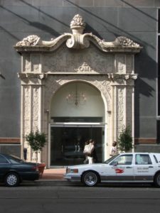
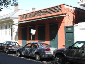
Figure 1. United Fruit Company building with a White Fleet taxicab in front. Credit: Andrew Sluyter
For a first, convenient stop among the sampling of spots to appreciate this particular dimension of the urban landscape, simply begin two blocks upriver from the Sheraton, at the corner of Saint Charles Avenue and Union Street in the CBD.[3] There the headquarters of the infamous United Fruit Company has become a bank, the company long since defunct. But during the early twentieth century, from behind the unforgettable façade of fruit laden cornucopia spilling down from the cornice of the ornate entrance, Sam “The Banana Man” Zemurray controlled the main flow of bananas into the U.S. from plantations in half a dozen countries in Latin America and the Caribbean (Figure 1). La Frutera or El Pulpo, as Latinos variously referred to the company, controlled everything in its supply chain from the banana trees to the White Fleet freighters that carried them, as well as the politics of the Central American countries that thereby became known as banana republics. The White Fleet has also persisted in a way, although no longer steaming up the Mississippi River with loads of bananas and Honduran immigrants; instead, you will see its name and pennant emblazoned on the doors of one of the city’s fleets of taxis.
Two blocks further upriver along Saint Charles Avenue, crossing Poydras Street toward the Warehouse District, now being rebranded as the Arts and Museum District, Lafayette Square invites relaxation in the largest greenspace near the conference hotels. In the nineteenth century filibusters rioted in Lafayette Square to burn the flag of the Spanish consulate after hearing of the defeat of an expedition to wrest Cuba from colonial rule. Filibusters, in fact, launched many of their campaigns against Caribbean and Latin American targets from New Orleans, and in 1847 U.S. troops mustered in the port before sailing for Veracruz during the Mexican-American War. A few blocks from Lafayette Square, where Poydras Street intersects Loyola Avenue, stands the monument to those soldiers who half a century later went to fight on Cuba and Puerto Rico during the Spanish-American War and did not return, but did help turn New Orleans into a major, neo-colonial refiner of Cuban sugar. You could also head in the other direction, toward the river, if interested in the Banana Wharf at the foot of Thalia Street or the Coffee Wharf at the foot of Poydras Street, but you would be disappointed because twentieth-century redevelopment for the Riverwalk Mall, Morial Convention Center, Crescent City Connection bridge, and Cruise Ship Terminal has obliterated the wharves that used to funnel commodities from the tropical Americas into the Crescent City and, from there, up the Mississippi River to the Midwest and beyond. Many Latinos who settled in the city because of the neo-colonial networks associated with bananas, coffee, and sugar initially lived just a few blocks upriver, in the Irish Channel neighborhood, before increasingly joining the “white flight” to suburban neighborhoods that began in the 1960s.
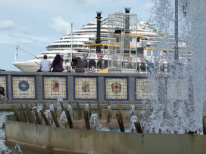
Figure 2. Spanish Plaza with a riverboat and a cruise liner behind. Credit: Andrew Sluyter
But head back downriver to where Canal Street meets the Mississippi River and you will encounter two prominent memorials of when New Orleans was a city in the Spanish colonial empire during the second half of the eighteenth century. Spanish Plaza, a large fountain built for the city by the Spanish government in 1976 is surrounded by a circular bench backed by the tiled crests of Spain’s provinces, a great spot atop the levee from which to enjoy the vista of the busy shipping of one of the world’s largest ports (Figure 2). On the other side of the World Trade Center, which so prominently marks the foot of Canal Street, another gift to the city from Spain also commemorates the 1776-1976 Bicentennial: an immense equestrian statue of Bernardo de Gálvez, the governor of Spanish “Luisiana” during the Revolutionary War, that celebrates how his troops defeated the British at the battles of Baton Rouge, Natchez, Pensacola, and Mobile.
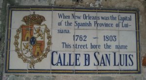
Figure 3. A street sign in the French Quarter. Credit: Andrew Sluyter
To get a better sense of what the city was like when a colonial capital, before the Louisiana Purchase of 1803, all you need to do is head downriver and cross Canal Street into the Quarter, which comprised the entire city during French and Spanish rule and, in some ways, remains unchanged. At every corner you will see the tiled signs that give the street names during Spanish times (Figure 3). The Plaza de Armas, now Jackson Square, provides the focal point, the river on one side and Saint Louis Cathedral on the other. The two buildings that flank the cathedral remain the most prominent vestiges of Spanish colonial architecture in the city: the arcaded Cabildo, or city hall, retains its Spanish name; the matching Casa Curial, or priests’ residence, has become the French Presbytère. The Mansard roofs added in the nineteenth century might deceive you, but if you imagine the two buildings without them, you might be looking at the colonial cabildo in Buenos Aires or some other city of the former Spanish colonial empire, fronted by an open plaza where troops could be mustered, overlooked by the cathedral and residences of prominent citizens.
The opposite, lakeside margin of the Quarter comprised the outskirts of the city during colonial times but also echoes the city’s lengthy connection to the Hispanic Atlantic. Along Basin Street, a block north of the Quarter in the Iberville neighborhood, Saint Louis Cemetery No. 1 was built in the eighteenth century during Spanish rule, its above-ground tombs similar to many throughout Spain and Latin America. The nearby Congo Square, now a part of Louis Armstrong Park, in the Tremé neighborhood provided a Sunday gathering place for the city’s enslaved residents, among the thousands brought from Africa to Louisiana aboard French and Spanish ships. There, on their day off, they could socialize, plot resistance, sing, and lay the foundations for what would become blues, jazz, and rock-and-roll.
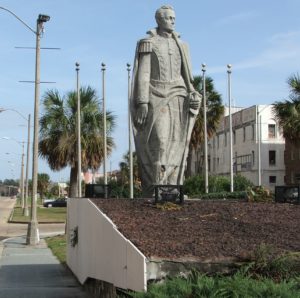
Figure 4. The Simón Bolívar statue in the Garden of the Americas. Credit: Andrew Sluyter
The Garden of the Americas occupies the Basin Street neutral ground, a term that originated when the median of Canal Street formed a neutral strip along the acrimonious frontier between the colonial Creoles who lived in the Quarter and the new, American residents who swarmed into the city after the Purchase and settled mainly upriver from the colonial core. After the Second World War, as part of a campaign to reassert itself as the North American “Gateway to Latin America” in the face of increasing competition from Houston, the city collaborated with local Latino organizations to establish the Garden of the Americas and its three enormous monuments to republican heroes of the Americas: Simón Bolívar for South America, Francisco Morazán for Central America, and Benito Júarez for Mexico (Figure 4).
Heading back toward the river, wander the narrow streets of the Quarter where Júarez and many other Latin American revolutionaries lived while in exile during the nineteenth century, plotting their various coups. In 1853, a young Élisée Reclus, who would become one of the foremost geographers and anarchists of the nineteenth century, also passed through the Quarter. He was headed upcountry to become a tutor to the children of his cousins at their Félicité plantation, about halfway to Baton Rouge along the Mississippi River, but he stopped long enough to observe that New Orleans at that time already had a lot of bars that were always full—some 2500 of them, apparently.[4] After more than two years in Louisiana, the experience of which helped shape his opposition to slavery and capitalism, Reclus left for Central and South America before returning to Paris in 1857 to write his La Terre: Description des Phénomènes de la Vie du Globe.
Figure 5. Spanish colonial residential architecture in the French Quarter. Credit: Andrew Sluyter
Not many houses remain from the colonial period due to the conflagrations that periodically swept across the Quarter. Compared to the residences built during French rule in the first half of the eighteenth century, those constructed during the succeeding Spanish period proved more fire resistant due to their stuccoed brick walls and flat roofs, but only a few examples have survived the construction boom of the nineteenth century that replaced almost all the colonial houses with ones built in neo-classical and Victorian styles. One of the few good examples of a typical Spanish house remains at 707 Dumaine Street (Figure 5). Otherwise, various balconies retain some fine examples of Spanish iron work, such as one at the corner of Royal and Conti Streets. Despite the disappearance of residential Spanish architecture over the nineteenth century, though, at least one Mexican sojourner of the time—Justo Sierra, in his 1895 book En Tierra Yankee—felt that New Orleans could still be counted among “those Gulf cities that all seem like sisters, but very large, very developed; Tampico, Veracruz, and Campeche would all fit within it, and it has something of all of them within it, of Veracruz above all.”
Other places of note for connoisseurs of Hispanic and Latino landscapes include the Bourbon Orleans Hotel, on Orleans Street immediately behind Saint Louis Cathedral, which served as the site of the 2017 Conference of Latin American Geographers. The Instrument Men fountain, located near the Dumaine Streetcar Station, depicts a classic jazz band and serves as a reminder that the city’s distinctive musical styles came into being partially through the influences of musicians who visited from Latin American and the Caribbean as well as local musicians who performed there and returned with innovations. As one dramatic example, albeit little known, the Mexican Military Band introduced the saxophone as well as the technique of plucking the bass violin when they played at the 1848 New Orleans World’s Fair.
Although more common in suburban neighborhoods like North Kenner, the Quarter has some Latino restaurants in which to gather to discuss how the city’s diverse roots have resulted in a “cultural gumbo,” to use the local metaphor. El Libre Cuban Café, for example, located near the foot of Dumaine Street, will serve you anything from a Cubano pressed sandwich or a guayaba pastry to a mojito cocktail or a cortadito coffee.
— Andrew Sluyter,executive director, Conference of Latin Americanist Geographers
[1] Once you arrive you will understand why upriver, downriver, riverside, and lakeside have long replaced cardinal directions in the Crescent City, although that sobriquet should already provide something of a clue.
[2] Andrew Sluyter, Case Watkins, James Chaney, and Annie M. Gibson. 2015. Hispanic and Latino New Orleans: Immigration and Identity since the Eighteenth Century. Baton Rouge: Louisiana State University Press (https://lsupress.org/books/detail/hispanic-and-latino-new-orleans).
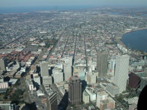
Skyscrapers in the New Orleans business district in the foreground contrast with the French Quarter in the background. Photo credit: Craig Colten
New Orleans battles with its identity. Locals see their home as a river city. Its European colonial founders etched a street grid across the narrow natural levee and perched the incipient city on the banks of the Mississippi River. Since then it has benefitted from waterborne commerce while battling high water that threatens its riparian site. The river loomed large in colonial life and looms large today.
Peirce Lewis, however, identified an uneasy relationship between the riverside site and maritime/inland hinterland situation when he labeled New Orleans as “the impossible but inevitable city.” The site on the banks of the river, had long been used by Native Americans as a strategic portage between the river and Lake Pontchartrain — in effect a bay of the Gulf of Mexico. The city’s French founder, Bienville, foresaw the importance of a city that could connect the vast North American hinterland with the Gulf and the French empire beyond. Indeed, colonial leaders abandoned two prior attempts to establish colonial capitals on the Gulf Coast before selecting the site about 100 miles upstream from the river’s mouth. Thus, the city is an heir of more direct coastal-oriented settlements, but reflects the significance of the river in its development. As the city celebrates it tricentennial in 2018, New Orleans may continue to see itself as a river city, but it functions very much as a Gulf Coast city on the banks of the Mississippi River.
Its relationship to the two water bodies remains thoroughly intertwined. In the years since 1718, the city’s economy has depended on the commerce coursing down the Mississippi – furs and cypress during the colonial era; corn, whiskey, hogmeat, sugar, and cotton during the antebellum period; grain and petrochemical products during much of the last century. New Orleans served as the entrepôt for this waterborne trade that relied on both the river and the Gulf. Another commercial tie has been tourism. Residents from across the Gulf South turned to New Orleans for a variety of pleasures since the 19th century, while New Orleans’s citizens have been prominent in the development of the Mississippi shore and visit the beaches of Alabama and Florida – furthering the city’s connections to the larger Gulf.
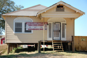
Elevated house after Hurricane Katrina. Credit: Craig Colten
Coping with hazards also reflects the city’s position at the intersection of fluvial and marine environments. Flood control efforts have focused on protecting the city while diverting risk via engineered floodways onto coastal fishermen in Mississippi Sound and near the mouth of the Atchafalaya River. Tropical weather presents a powerful threat from the warm waters of the Gulf of Mexico, and with the loss of it coastal wetlands, New Orleans is ever closer to the Gulf and to storm surges driven by cyclones. After Hurricane Katrina in 2005, some homeowners reluctantly raised their houses on stilts, like beach houses – a concession to their coastal location.When the BP oil platform erupted in a tragic fire in April 2010 and released millions of gallons of crude into the Gulf, neighboring coastal states faced economic catastrophe as the slick washed onto their sandy beaches and drove tourists away. Florida’s governor criticized Louisiana for carelessly developing its offshore oil resources which he saw as a threat to his state’s economy. Residents of New Orleans complained that they could smell the oil from off shore – emphasizing their proximity to the Gulf.
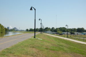
Mississippi River levee during high river in 2011 at Baton Rouge. Photo credit: Craig Colten
Based on its role as entrepôt to the Mississippi River valley, New Orleans was among the country’s five largest cities on the eve of the Civil War. Levees obstructed the view of the river although they did not impede commerce, and these structures became one of the dominating features of the lower river landscape.The Civil War diverted Midwestern commerce to the eastern seaboard by rail, and New Orleans declined in the rank order of the country’s cities. The conflict also left the levees in a poor state of repair and a flood in 1874 provided a political tipping point in a long-running campaign to pass the costs of levee construction and maintenance to the federal government. At the urging of Southern planters and politicians Congress passed legislation in 1879 to fund and maintain the levees, not for flood protection of the recently rebellious region, but to maintain a navigable waterway for interstate commerce. By the early 20th century, engineers abandoned the mistaken belief that the river confined by levees would maintain a deep channel. Following several floods culminating in the most tragic U.S. flood on record in 1927, the Mississippi River Commission declared the main purpose of levees was to fend off inundation and not enable commerce. Despite the fact that the flood of record did not inundate New Orleans, it prompted massive re-engineering of the river that was oriented toward protecting New Orleans and its shipping interests. Its role as the entrepôt connecting the Mississippi River to the Gulf of Mexico remained a dominating concern.
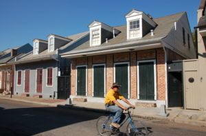
Creole cottage in the French Quarter. Photo credit: Craig Colten
With its distinctive French and Spanish colonial heritage, a sizable number of African Americans, along with later Anglo, German, and Italian immigrants, New Orleans may have fallen in its ranking among the country’s largest cities, but it emerged in the 1800s as the largest Gulf Coast city of what Terry Jordan called the Creole Coast. With a legal system based on French civil code, a persistent French-speaking population well into the 19th century, culinary traditions from France, Spain, Africa, and indigenous populations, it became a most peculiar place. African and European cooks and chefs combined local seafood, rice, and spices from multiple hearths to fashion a creole cuisine that is a hallmark of the city’s culture today. Building traditions from Africa and Europe created a landscape unlike other American cities. Celebrations, most notably Mardi Gras, have incorporated elements of the Catholic sacred calendar with Caribbean and African influences to produce arguably the city’s best known spectacle each spring. In addition, Afro-Caribbean rhythms blended with European brass instruments to give rise to jazz.
One could argue that New Orleans thrives on these important elements of its past. Visitors flock to stroll through the narrow streets of the French Quarter, to sample the spicy creole fare, to enjoy the seductive rhythms and melodies in the jazz clubs, and to forget their cares along the parade routes during Mardi Gras. And beyond the well-worn tourist paths, there are countless lesser-known architectural, culinary, and musical treasures. Of course, the city is highly cognizant of its rich history and aggressively seeks to parley that into heritage tourism income. Indeed, in 2015 tourists spend over $7 billion dollars in the city. Tourism has largely recovered from the downturn after 9/11, the devastating decline caused by the hurricanes Katrina and Rita, and the Great Recession a decade ago.
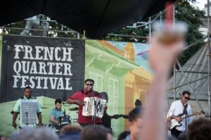
French Quarter Festival. Zack Smith Photography, courtesy of French Quarter Festivals, Inc.
Always looking for a way to expand its tourism calendar, the city supports numerous special events to attract visitors beyond the Mardi Gras season. The Jazz and Heritage Fest held each spring is one of the world’s premier music festivals. Operating since 1970, it began as a celebration of regional music — jazz, gospel, rhythm and blues, and Acadian sounds. It still features local talent and traditions, but has exploded into an international event drawing major popular music performers. There are countless other festivals — such as the Essence Music Fest, the Voodoo Music Fest, the Cajun and Zydeco Fest, the Satchmo Fest, along with Southern Decadence, the Creole Tomato Fest, the Oyster Fest, and the Oak Street Po-boy fest. Plus there are sports events such as the Sugar Bowl, the Crescent City Classic Marathon, and periodic NCAA championships. The annual calendar ensures that most visitors who stay even a few days will be able to participate in one of these celebrations. Indeed one the most noteworthy events will overlap with the AAG meeting in New Orleans — The French Quarter Fest.
The French Quarter Fest was created to showcase local musical performers on multiple outdoor stages in and near the French Quarter. Initially, a “locals” event it offered free performances in the midst of the city’s historic district where local cuisine was available around every corner. It has grown but still offers a more intimate setting than that sprawling Jazz Fest, and admission is FREE. The festival’s web site [https://fqfi.org/] boasts that it will host 300 hours of entertainment by 400 performers during its run from April 12 to 15, 2018. It is truly one of the jewels of the city’s festival calendar, and it falls at a time when weather is generally quite pleasant and conducive to a street festival.
New Orleans has persisted in a perilous place for three centuries now and in that time it has given rise to a rich array of visual, auditory, and gustatory experiences. After the 2005 hurricane season, some questioned whether it made economic sense to rebuild the devastated city. Some 20 percent of the city’s population were not certain about the safety of returning and stayed away. Yet, rebuilding and denying risk, along with celebrating at the drop of a hat, are things that the people of New Orleans and the Gulf Coast excel at. Long-time residents are deeply attached to this quirky place, and new arrivals since 2005 came to get a taste of the traditions that endure, even if altered by the newcomers and their influences.
In the face of a disappearing coast, there is grave concern about the long-term future of the city and the outlying wetlands. Louisiana is investing huge sums of money to offset the encroachment of the Gulf across its coastal marshes. But with the highest rate of relative sea-level rise in the U.S., this deltaic coast will certainly change in the coming decades. How that will impact the city has yet to be seen and uncertainty hangs over the city like another layer of humidity. But we encourage you to come pay us a visit while you can.
— Craig Colten, Louisiana State University
Recommended reading, by geographers for geographers:
Also visit the web page of the unofficial “Geographer in Residence” of New Orleans, Richard Campanella and his Geographer’s Space in the Louisiana Endowment for the Humanities’ Cultural Vistas
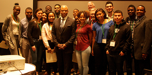
AAG Launches Emerging Workforce Scholars Program at Annual Meeting
This year, AAG launched the Emerging Workforce Scholars program, a unique three-day careers pathway exploration at the 2017 Annual Meeting in Boston. Fourteen highly motivated, diverse students from Boston’s community colleges, high schools and youth programs were introduced to careers in the environment, sustainable infrastructure and the tools of applied geography and geosciences. AAG partnered with the Boston Private Industry Council (PIC) to recruit, vet and train this cohort of highly-qualified students. The Boston Mayor’s Office of Workforce Development and the Massachusetts Secretary of Labor and Workforce Development (Hon. Ronald L. Walker, II) were also an integral part of making this project a resounding success.
The program began with a full day of visits to four operating facilities – Massport/Logan Airport, Deer Island Wastewater Treatment plant, the Wind Technology Large Blade Test Center, and Casella Recycling. At each facility, students met and interacted with HR reps, managers and employees to learn first-hand about job and career opportunities and the skills needed to enter and succeed in each arena.
On day two, students participated in the AAG meeting itself and found out about the incredibly diverse offerings in the field of geography. They attended technical sessions and explored the Exhibit Hall, making contact with and getting information from different exhibitors that interested them.
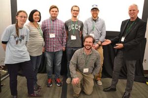
The final day started with an interactive professional skills development workshop called “Get the Knowledge You Don’t Get in College.” AAG Executive Director Doug Richardson welcomed the panel on “Careers in Sustainable Infrastructure and Technology.” The audience then heard about the initiatives of the Mayor’s Office of Workforce Development (Trinh Nguyen), IBM’s “P-Tech” and “Extreme Blue” training programs (Cathleen Finn), Northeastern University’s externships (Maria Stein) and careers in clean energy/clean tech from BW Research (Phil Jordan). AAG Council member Darren Purcell was also present and he spent the afternoon fully engaged in conversations with the scholars, panelists and Secretary Walker.
AAG President Glen MacDonald was on hand to introduce Secretary Walker who then engaged in an informal chat with AAG’s project consultant Drew Lehman and the students. Secretary Walker closed out the program with a recognition ceremony, handing out certificates of completion to each of the scholars. The response from the participants and all involved has been overwhelmingly positive, from the students, to the governments, schools and private industry sponsors, to the AAG leadership whose support made this program possible.
Keynote by Hon. Sec. Ronald L. Walker, Massachusetts Secretary of Labor: Massachusetts’s Workforce Investment Programs and AAG Emerging Workforce Scholars Recognition Ceremony. (Photo by Jenn Bailey)
Share
Annual Meeting
Great Plains/Rocky Mountains Division Team Takes 2017 World Geography Bowl Title
AAG President Glen MacDonald (far right) presented prizes to winners, including the winning Great Plains/Rocky Mountains Division team above. (Photograph for AAG by Becky Pendergast)
The Great Plains/Rocky Mountains Division team won first place in the 2017 World Geography Bowl (WGB), an annual quiz competition for teams of college-level geography students representing the AAG’s regional divisions. First runner-up was Southeast Division team and second runner-up was the Southwest Division team. This was the 24th year for AAG hosting during its Annual Meeting in Boston.
Contestants are selected by regional divisions via a competitive process, which in many divisions includes participation in a regional geography bowl held at the regional division’s annual meeting. Each participant in the World Geography Bowl receives a travel stipend, co-sponsored by the AAG and that student’s regional division, greatly offsetting expenses for attendance at the national meeting.
The competition is fully staffed by volunteers, who write and edit questions and help run the proceedings as judges, scorekeepers, and moderators. To become involved, read more about the process or contact WGB executive director Jamison Conley, (West Virginia U.) at Jamison [dot] Conley [at] mail [dot] wvu [dot] edu.
Anyone interested in becoming a sponsor or donating prizes of books, gift certificates, software, etc., may contact AAG’s WGB liaison Kelsey Taylor at ktaylor [at] aag [dot] org.
Note: This post has been updated to state that this was the 24th year the bowl was held. A previous version erroneously stated that this was the 28th year.
Share
Annual Meeting
AAG 2017 Boston Annual Meeting PDF Program
Share
Annual Meeting
2017 Annual Meeting Program: Boston, MA
Share
Post
AAG 2017 Boston Featured Theme — Mainstreaming Human Rights in Geography and the AAG
AAG 2017 Boston — Featured Theme
Mainstreaming Human Rights in Geography and the AAG
This special theme will feature 50 sessions with more than 250 presentations at the intersection of human rights and geography and will build on the AAG’s decade-long initiatives in this area. Speakers from leading international human rights organizations, academia, government, and NGOs will address human rights challenges around the world.
In the keynote plenary, “A Continuing Conversation with Noam Chomsky,” Noam Chomsky will engage in a conversational interview with AAG Executive Director Doug Richardson. The audience will also have an opportunity to ask questions following the interview. In addition, Chomsky will receive the 2017 AAG Atlas Award, the association’s highest honor. Be sure and add to your calendar this important keynote session scheduled for Thursday, April 6, 2017, from 5:20 p.m. – 7:00 p.m. in Ballroom B of the Hynes Convention Center.
Another high-profile Human Rights session, “International Human Rights Priorities: Featured Perspectives,” features panelists Terry Rockefeller, Board of Directors, Amnesty International USA; Michael Posner, NYU Stern Center for Business and Human Rights and former Assistant Secretary of State for the Bureau of Democracy, Human Rights and Labor at the State Department; Beth Simmons, Andrea Mitchell University Professor of Law and Political Science, University of Pennsylvania; Jessica Wyndham, AAAS Scientific Responsibility, Human Rights and Law Program; Tawanda Mutasah, Amnesty International and Douglas Richardson, Executive Director, American Association of Geographers. This session is scheduled on Saturday, April 8, 2017, from 1:20 p.m. – 3:00 p.m. in Room 103, on the Plaza level of the Hynes Convention Center.
Rush Holt, chief executive officer of the American Association for the Advancement of Science (AAAS), will deliver a featured talk on “Advancing Science in the Public Arena,” on Thursday, April 6, from 11:50 a.m. – 1:10 p.m. in Room 103 of the Hynes Convention Center.
Noam Chomsky, Audrey Kobayashi, Doug Richardson, Jessica Wyndham, Tawanda Mutasah, Sheryl Luzzadder-Beach, James Hansen and Colette Pichon Battle
Organizing Committee: Douglas Richardson, Chair (AAG), Sheryl Beach (University of Texas), Jessica Wyndham (American Association for the Advancement of Science), Audrey Kobayashi (Queen’s University)
You can easily add sessions and events of interest to your schedule in theAAG Mobile App or in your online program.
Share
Post
AAG 2017 Boston Special Policy Events — The 2016 U.S. Elections: Implications for Geography and Beyond
AAG 2017 Boston — Special Policy Events
The 2016 U.S. Elections: Implications for Geography and Beyond
This series of sessions will focus on analysis and research on the 2016 U.S. election, and what the results may mean for geography, the nation, and our planet.
This special track features the session, “The 2016 U.S. Elections: Implications for Geography and Beyond,” a high-profile panel session, chaired and organized by AAG President Glen M. MacDonald, with Sarah Witham Bednarz, Texas A&M University; Alexander B. Murphy, University of Oregon; Douglas Richardson, American Association of Geographers; Derek H. Alderman, University of Tennessee; Victoria A. Lawson, University of Washington; Julie Winkler, Michigan State University, among others. This special session will be held on Saturday, April 8, 2017, from 5:20 p.m. – 7:00 p.m. in Room 312 of the Hynes Convention Center in Boston.
AAG Members get exclusive access to publications, prominent journals, unique advocacy, grant, scholarship and professional opportunities with access to industry focus communities, and event discounts, including our annual meeting.
Some content may only be accessible if you belong to specific Specialty or Affinity Groups. You can still update your membership below. You will need to go through the Join flow, but you do not need to repurchase your membership unless it is expired or about to expire.
To provide the best experiences, we use technologies like cookies to store and/or access device information. Consenting to these technologies will allow us to process data such as browsing behavior or unique IDs on this site. Not consenting or withdrawing consent, may adversely affect certain features and functions.
Functional
Always active
The technical storage or access is strictly necessary for the legitimate purpose of enabling the use of a specific service explicitly requested by the subscriber or user, or for the sole purpose of carrying out the transmission of a communication over an electronic communications network.
Preferences
The technical storage or access is necessary for the legitimate purpose of storing preferences that are not requested by the subscriber or user.
Statistics
The technical storage or access that is used exclusively for statistical purposes.The technical storage or access that is used exclusively for anonymous statistical purposes. Without a subpoena, voluntary compliance on the part of your Internet Service Provider, or additional records from a third party, information stored or retrieved for this purpose alone cannot usually be used to identify you.
Marketing
The technical storage or access is required to create user profiles to send advertising, or to track the user on a website or across several websites for similar marketing purposes.

 This special theme will feature 50 sessions with more than 250 presentations at the intersection of human rights and geography and will build on the AAG’s decade-long initiatives in this area. Speakers from leading international human rights organizations, academia, government, and NGOs will address human rights challenges around the world.
 This series of sessions will focus on analysis and research on the 2016 U.S. election, and what the results may mean for geography, the nation, and our planet.